August 30, 2010

Our new Flash World Map
Seven months ago we began selling a USA flash map. Since that time we’ve been tweaking the map as we’ve spoken with customers and learned more about Flash. This experience has been invaluable as we’ve worked on our latest project. It’s my pleasure to announce that we’ve just launched a brand new interactive flash world map at flashworldmap.com
Relative to a United States map, a world map introduces a bunch of new challenges. Our map introduces two new innovations that are currently unavailable on the market:
1. Smart Zooming
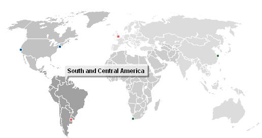
There are around 170 countries in the world and many of them are quite small. How do you fit that level of detail on a standard computer screen? You need some way to zoom. But, traditional “zoom in” and “zoom out” bar’s (think Google maps) are clunky and distracting. It’s hard enough to keep visitors focused on your map’s content without without requiring them to fidget with the zoom. So, we invented “Smart Zooming” at the continent level. Continents can be transparent so you can see the color of the countries underneath (which is great for displaying statistics). Click on a continent and the map automatically zooms in to an appropriate level. Click on an adjacent continent and the zoom automatically adjusts. This makes the interface attractive and zooming second nature.
2.Latitude/Longitude Markers on a Robinson Projection
The world is round. A computer screen is flat. That means the globe most be projected into two dimensions. One of the most popular and elegant projections available is the Robinson projection. However, many flash maps use a projection that flattens and distorts the earth. This looks ugly, but makes it easy to use latitude and longitude to create location markers. Other maps, use the prettier Robinson projection, but don’t offer pinpoint locations. Our map offers the convenience of pinpoint locations using latitude and longitude along with the beauty of a Robinson map. This feature took a lot of time and effort, but truly makes our map unique.
As always, our product sets itself apart by including the full-source code and a 30-day money back guarantee. We’ve also avoided many of the bugs that arose while developing our US map. If you’re on the market for a world map, please download a trial copy and test it out. It won’t disappoint.
Relative to a United States map, a world map introduces a whole bunch of new challenges. Our map introduces two new innovations that are currently unavailable on the market:
1. Smart Zooming
There are around 170 countries in the world and many of them are quite small. How do you fit that level of detail on a standard computer screen? You need some way to zoom. But, traditional “zoom in” and “zoom out” bar’s (think Google maps) are clunky and distracting. It’s hard enough to keep visitors focused on your map’s content without without requring them to fidgit with the zoom. So, we invented transparent “Smart Zooming” at the continent level. Click on a continent and the map automatically zooms in to an appropriate level. Click on an adjacent continent and the zoom automatically adjusts. This makes the interface attractive and zooming second nature.
2. Pinpoint Locations on a Robinson Projection
The world is round. A computer screen is flat. That means the globe most be projected into two dimensions. One of the most popular and elegant projections available is the Robinson projection. However, many flash maps use a projection that flattens and distorts the earth. This looks ugly, but makes it easy to use latitude and longituge to create location markets. Other maps, use the prettier Robinson projection, but don’t offer pinpoint locations. Our map offers the convienence of pinpoint locations using latitude and longitude along with the beauty of a Robinson map. This feature took a lot of time and effort, but truly makes our map stand out.
As always, our map sets itself apart by offering the full-source code and a 30-day money back guarentee. We’ve also avoided many of the bugs that came up while developing our US map. If you’re on the market for a world map, please download a trial copy and test it out. We think you’ll be impressed.
Home | License | Privacy | Releases | Testimonials | Resources | Documentation | Order Lookup | All Maps | FAQs
Formerly FlashUSAmap.com and FlashWorldMap.com
SimpleMaps.com is a product of Pareto Software, LLC. © 2010-2025.