We're proud to offer a simple, accurate and up-to-date database of the world's cities and towns.
We've built it from the ground up using authoritative sources such as the NGIA, US Geological Survey, US Census Bureau, and NASA.


Our database is:
Databases | Basic | Pro | Comprehensive |
|---|---|---|---|
| Commercial use | Allowed | Allowed | Allowed |
| File format | CSV, Excel | CSV, SQL (too large for Excel) | CSV or SQL (too large for Excel) |
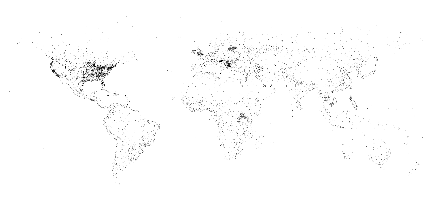
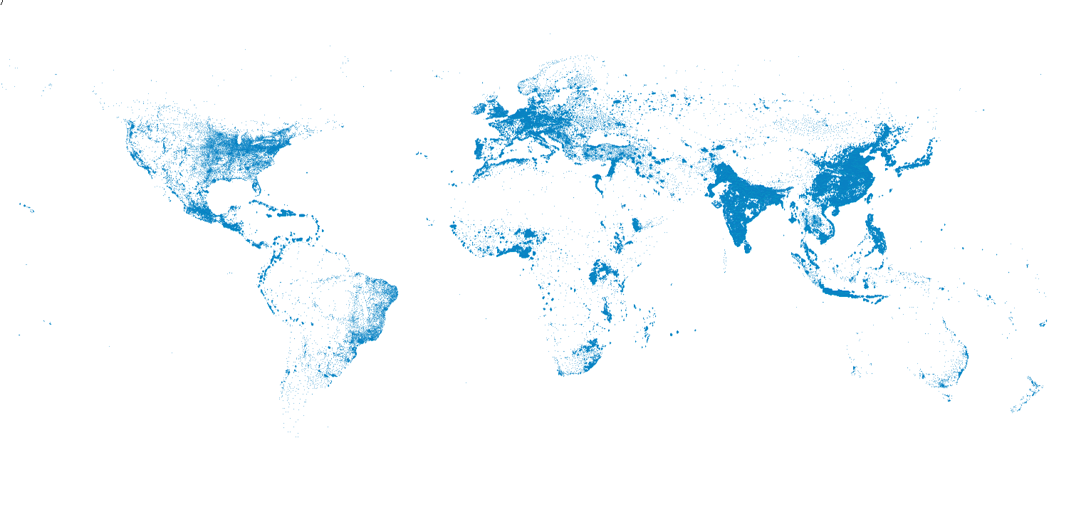
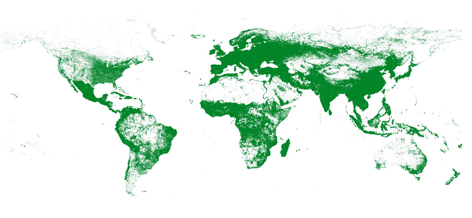
| Type of cities | Prominent cities (large, capitals etc.) | Most cities and towns | All populated places |
| Number of entries | 50.2 thousand | 2.0 million | 4.4 million |
| Future updates | Not guaranteed | Included for 12 months | Included for 24 months |
| Data last updated | 2026 | 2026 | 2026 |
| Attribution | Required | Not required | Not required |
| License | Creative Commons Attribution 4.0 | Permissive, no redistribution | Permissive, no redistribution |
| Refund policy | N/A | 30-day guarantee | 30-day guarantee |
| One-time fee | Free | $199 | $499 |
| Buy Now! | Buy Now! |
Here is a sample of rows from the comprehensive database:
Due to space constraints, not all fields are shown. For an exact representation, download this sample (Excel, CSV) of France.
| fieldname | description | Basic | Pro | Comp. |
|---|---|---|---|---|
city |
The name of the city/town as a Unicode string (e.g. Goiânia). | |||
city_ascii |
city as an ASCII string (e.g. Goiania). Left blank if ASCII representation is not possible. |
|||
city_alt |
Alternative city names, separated by a vertical bar (e.g. Goyania|Goianá) | |||
city_local |
The name of the city in the local language (e.g. 北京 for Beijing, China). Not available for all cities. | |||
city_local_lang |
The 3-character language code for city_local. Not always available. (e.g. zho).
|
|||
lat |
The latitude of the city/town. | |||
lng |
The longitude of the city/town. | |||
country |
The name of the city/town's country. | |||
iso2 |
The alpha-2 iso code of the country. |
|||
iso3 |
The alpha-3 iso code of the country. |
|||
admin_name |
The name of the highest level administration region of the city town (e.g. a US state or Canadian province). Based on the GENC profile of the ISO 3166-2 standard. Possibly blank. | |||
admin_name_ascii |
admin_name as an ASCII string. |
|||
admin_code |
The iso code for the admin. Length varies by country. |
|||
admin_type |
A description of the admin. (e.g. province, state, municipal district etc.) |
|||
capital |
Blank string if not a capital, otherwise: primary - country's capital (e.g. Washington D.C.) admin - first-level admin capital (e.g. Little Rock, AR) minor - lower-level admin capital (e.g. Fayetteville, AR) |
|||
density |
An estimate of the population per square kilometer at the lat/lng. Derived from 2020 data. |
population |
An estimate of the city's urban population. Only available for some (prominent) cities. If the urban population is not available, the municipal population is used. | population_proper |
An estimate of the city's municipal population. Only available for some (prominent) cities. We only count the municipal population that lies within the urban area so population_proper will always be smaller than or equal to population. |
timezone |
The city's timezone in the tz database format. (e.g. America/Los_Angeles) | ranking |
An integer from 1-5 that captures the importance of a city (1 is most important, 5 least important). | same_name |
TRUE if the place has the same exact name as a more important place in the same country, and admin_name. Many users choose to drop these relatively unimportant places with conflicting names. |
id |
A 10-digit unique id generated by SimpleMaps. We make every effort to keep it consistent across releases and databases (e.g. U.S Cities Database). |
What counts as a city/town?
Any populated place in the world as determined by U.S. government agencies. Neighborhoods within listed cities are not included.
Were does your data come from?
Cities for all non-U.S. countries comes from the National Geospatial-Intelligence Agency. US cities data comes from the U.S. Census Bureau and the U.S. Geological Survey. Population data comes from various sources. Population density data comes from the Center for International Earth Science Information Network at Columbia University in partnership with NASA's Socioeconomic Data and Applications Center. We've made a concerted effort to source our data from public domain and permissively-licensed sources that will not restrict the rights of our customers.
How do you address border conflicts and territorial disputes?
We simply use the determination of our primary source which is a U.S. government agency.
Since most of this data is in the public-domain, what value are you adding?
We've spent countless hours: downloading, merging, cleaning, formatting, and aggregating this data into an accurate and concise product.
What am I allowed to do if I purchase the Comprehensive Database license?
A license allows you to use the database internally or to query the database for public-facing applications that you or your organization owns or develops. Attribution is not required. You are not allowed to publicly redistribute the database without prior permission. You can make copies of the database for internal and backup purposes. To learn more, read the full license terms.
Why should I trust this data?
This database was aggregated from authoritative sources and carefully processed by SimpleMaps. We've been developing and selling interactive maps to Fortune 500 companies and prominent international organizations for over 16 years. Over this time, we've learned a lot about geographic data. Our data products have been used in production by well-regarded organizations such as The Guardian. To get a sense of the expertise, check out some of the testimonials from our happy customers.
How do I calculate the distance between two cities?
We've published free formulas in popular programming languages. Check them out.
Can I get the Pro or Comprehensive Database in Excel or SQL server?
The Comprehensive Database can be downloaded in CSV or SQL (MySQL) format upon purchase. The database has too many rows to fit in a single Excel worksheet, but we can provide the data in Excel format, broken out by country, upon request. We can also provide the data as a .bak file for SQL server. Please contact us to receive the data in one of these formats.
What's the fastest way to import the comprehensive database into MySQL?
We recommend using the CSV file and following our tutorial on importing a CSV into MySQL.
Can I purchase additional updates?
Yes. After updates expire, you can purchase 12 more months of updates for $99 (Pro) or $199 (Comprehensive).
What is the difference between the Pro and Comprehensive databases?
The main difference between the two is that the Pro database generally only includes cities and towns that either have a ranking of 1, 2, or 3 while the Comprehensive database includes all cities and towns for which we have data. For most users, the Pro database is sufficient and will be faster to query.
Does the data include population data for every place in the world?
No, that would not be possible to do. The database includes all named places in the world where people work and live. This includes a large number of small rural villages. In many such places population data is not collected by the government or is very difficult to source. We currently have population data for prominent places. These are typically cities and large towns. The aggregate sum of our population data is over 4.6 billion people and we continue to add to this with each release. We do provide an estimate of density for all places and an estimate of importance, ranking, that can be used for sorting purposes.
The database includes data on 248 countries. The included countries are as follows.
{
"AF","Afghanistan",
"QZ","Akrotiri",
"AL","Albania",
"DZ","Algeria",
"AS","American Samoa",
"AD","Andorra",
"AO","Angola",
"AI","Anguilla",
"AG","Antigua and Barbuda",
"AR","Argentina",
"AM","Armenia",
"AW","Aruba",
"AU","Australia",
"AT","Austria",
"AZ","Azerbaijan",
"BS","Bahamas, The",
"BH","Bahrain",
"BD","Bangladesh",
"BB","Barbados",
"BY","Belarus",
"BE","Belgium",
"BZ","Belize",
"BJ","Benin",
"BM","Bermuda",
"BT","Bhutan",
"BO","Bolivia",
"BQ","Bonaire, Sint Eustatius, and Saba",
"BA","Bosnia and Herzegovina",
"BW","Botswana",
"BR","Brazil",
"IO","British Indian Ocean Territory",
"BN","Brunei",
"BG","Bulgaria",
"BF","Burkina Faso",
"MM","Burma",
"BI","Burundi",
"CV","Cabo Verde",
"KH","Cambodia",
"CM","Cameroon",
"CA","Canada",
"KY","Cayman Islands",
"CF","Central African Republic",
"TD","Chad",
"CL","Chile",
"CN","China",
"CX","Christmas Island",
"CC","Cocos (Keeling) Islands",
"CO","Colombia",
"KM","Comoros",
"CG","Congo (Brazzaville)",
"CD","Congo (Kinshasa)",
"CK","Cook Islands",
"CR","Costa Rica",
"CI","Côte d’Ivoire",
"HR","Croatia",
"CU","Cuba",
"CW","Curaçao",
"CY","Cyprus",
"CZ","Czechia",
"DK","Denmark",
"XD","Dhekelia",
"DJ","Djibouti",
"DM","Dominica",
"DO","Dominican Republic",
"EC","Ecuador",
"EG","Egypt",
"SV","El Salvador",
"GQ","Equatorial Guinea",
"ER","Eritrea",
"EE","Estonia",
"SZ","Eswatini",
"ET","Ethiopia",
"FK","Falkland Islands (Islas Malvinas)",
"FO","Faroe Islands",
"FJ","Fiji",
"FI","Finland",
"FR","France",
"GF","French Guiana",
"PF","French Polynesia",
"TF","French Southern and Antarctic Lands",
"GA","Gabon",
"GM","Gambia, The",
"XG","Gaza Strip",
"GE","Georgia",
"DE","Germany",
"GH","Ghana",
"GI","Gibraltar",
"GR","Greece",
"GL","Greenland",
"GD","Grenada",
"GP","Guadeloupe",
"GU","Guam",
"GT","Guatemala",
"GG","Guernsey",
"GN","Guinea",
"GW","Guinea-Bissau",
"GY","Guyana",
"HT","Haiti",
"HN","Honduras",
"HK","Hong Kong",
"HU","Hungary",
"IS","Iceland",
"IN","India",
"ID","Indonesia",
"IR","Iran",
"IQ","Iraq",
"IE","Ireland",
"IM","Isle of Man",
"IL","Israel",
"IT","Italy",
"JM","Jamaica",
"JP","Japan",
"JE","Jersey",
"JO","Jordan",
"KZ","Kazakhstan",
"KE","Kenya",
"KI","Kiribati",
"KP","Korea, North",
"KR","Korea, South",
"XK","Kosovo",
"KW","Kuwait",
"KG","Kyrgyzstan",
"LA","Laos",
"LV","Latvia",
"LB","Lebanon",
"LS","Lesotho",
"LR","Liberia",
"LY","Libya",
"LI","Liechtenstein",
"LT","Lithuania",
"LU","Luxembourg",
"MO","Macau",
"MG","Madagascar",
"MW","Malawi",
"MY","Malaysia",
"MV","Maldives",
"ML","Mali",
"MT","Malta",
"MH","Marshall Islands",
"MQ","Martinique",
"MR","Mauritania",
"MU","Mauritius",
"YT","Mayotte",
"MX","Mexico",
"FM","Micronesia, Federated States of",
"MD","Moldova",
"MC","Monaco",
"MN","Mongolia",
"ME","Montenegro",
"MS","Montserrat",
"MA","Morocco",
"MZ","Mozambique",
"NA","Namibia",
"NR","Nauru",
"NP","Nepal",
"NL","Netherlands",
"NC","New Caledonia",
"NZ","New Zealand",
"NI","Nicaragua",
"NE","Niger",
"NG","Nigeria",
"NU","Niue",
"NF","Norfolk Island",
"MK","North Macedonia",
"MP","Northern Mariana Islands",
"NO","Norway",
"OM","Oman",
"PK","Pakistan",
"PW","Palau",
"PA","Panama",
"PG","Papua New Guinea",
"XP","Paracel Islands",
"PY","Paraguay",
"PE","Peru",
"PH","Philippines",
"PN","Pitcairn Islands",
"PL","Poland",
"PT","Portugal",
"PR","Puerto Rico",
"QA","Qatar",
"RE","Reunion",
"RO","Romania",
"RU","Russia",
"RW","Rwanda",
"BL","Saint Barthelemy",
"SH","Saint Helena, Ascension, and Tristan da Cunha",
"KN","Saint Kitts and Nevis",
"LC","Saint Lucia",
"MF","Saint Martin",
"PM","Saint Pierre and Miquelon",
"VC","Saint Vincent and the Grenadines",
"WS","Samoa",
"SM","San Marino",
"ST","Sao Tome and Principe",
"SA","Saudi Arabia",
"SN","Senegal",
"RS","Serbia",
"SC","Seychelles",
"SL","Sierra Leone",
"SG","Singapore",
"SX","Sint Maarten",
"SK","Slovakia",
"SI","Slovenia",
"SB","Solomon Islands",
"SO","Somalia",
"ZA","South Africa",
"GS","South Georgia and South Sandwich Islands",
"SS","South Sudan",
"ES","Spain",
"LK","Sri Lanka",
"SD","Sudan",
"SR","Suriname",
"XR","Svalbard",
"SE","Sweden",
"CH","Switzerland",
"SY","Syria",
"TW","Taiwan",
"TJ","Tajikistan",
"TZ","Tanzania",
"TH","Thailand",
"TL","Timor-Leste",
"TG","Togo",
"TK","Tokelau",
"TO","Tonga",
"TT","Trinidad and Tobago",
"TN","Tunisia",
"TR","Turkey",
"TM","Turkmenistan",
"TC","Turks and Caicos Islands",
"TV","Tuvalu",
"VI","U.S. Virgin Islands",
"UG","Uganda",
"UA","Ukraine",
"AE","United Arab Emirates",
"GB","United Kingdom",
"US","United States",
"UY","Uruguay",
"UZ","Uzbekistan",
"VU","Vanuatu",
"VA","Vatican City",
"VE","Venezuela",
"VN","Vietnam",
"VG","Virgin Islands, British",
"WF","Wallis and Futuna",
"XW","West Bank",
"YE","Yemen",
"ZM","Zambia",
"ZW","Zimbabwe"
}
Home (Maps) | Database License | Privacy | Database Releases | Database Order Lookup | Resources | Contact | FAQs
SimpleMaps.com is a product of Pareto Software, LLC. © 2010-2026.