We're proud to offer a simple, accurate and up-to-date database of US hospitals and medical facilities. Built from Medicare certification data, US Census Bureau geographic data, and other authoritative sources, it includes detailed facility information including trauma levels, bed counts, emergency services, and GIS building footprints.


Heat map showing the density of Level I adult trauma centers across the US. Dark red indicates high density (hospitals nearby); light red indicates low density (hospitals farther away).
Databases | Basic | Pro | Comprehensive |
|---|---|---|---|
| Commercial use | Allowed | Allowed | Allowed |
| File format | CSV, Excel | CSV, Excel, SQL | CSV, Excel, SQL, SHP, GeoJSON |
| Number of entries | 5,768 | 5,768 | 5,768 |
| Fields (listed below) | Basic fields | All fields | All fields |
| GIS/Shapefile | Not included | Not included | Included |
| Future updates | Not guaranteed | Included for 12 months | Included for 24 months |
| Attribution (CSV/Excel/SQL) | Required | Not required | Not required |
| Attribution (GIS Polygons) | N/A | N/A | Required attribution of OpenStreetMap under ODbL |
| License (CSV/Excel/SQL) | Creative Commons Attribution 4.0 | Permissive, no redistribution | Permissive, no redistribution |
| License (GIS Polygons) | N/A | N/A | ODbL — redistribution allowed |
| Refund policy | N/A | 30-day guarantee | 30-day guarantee |
| One-time fee | Free | $399 (USD) | $999 (USD) |
| Buy Now! | Buy Now! |
Here is a sample of rows from the database with some commonly-used fields:
The Comprehensive version includes GIS shapefiles and GeoJSON files containing hospital building footprints sourced from OpenStreetMap. These are compatible with ArcGIS, QGIS, and other GIS software.
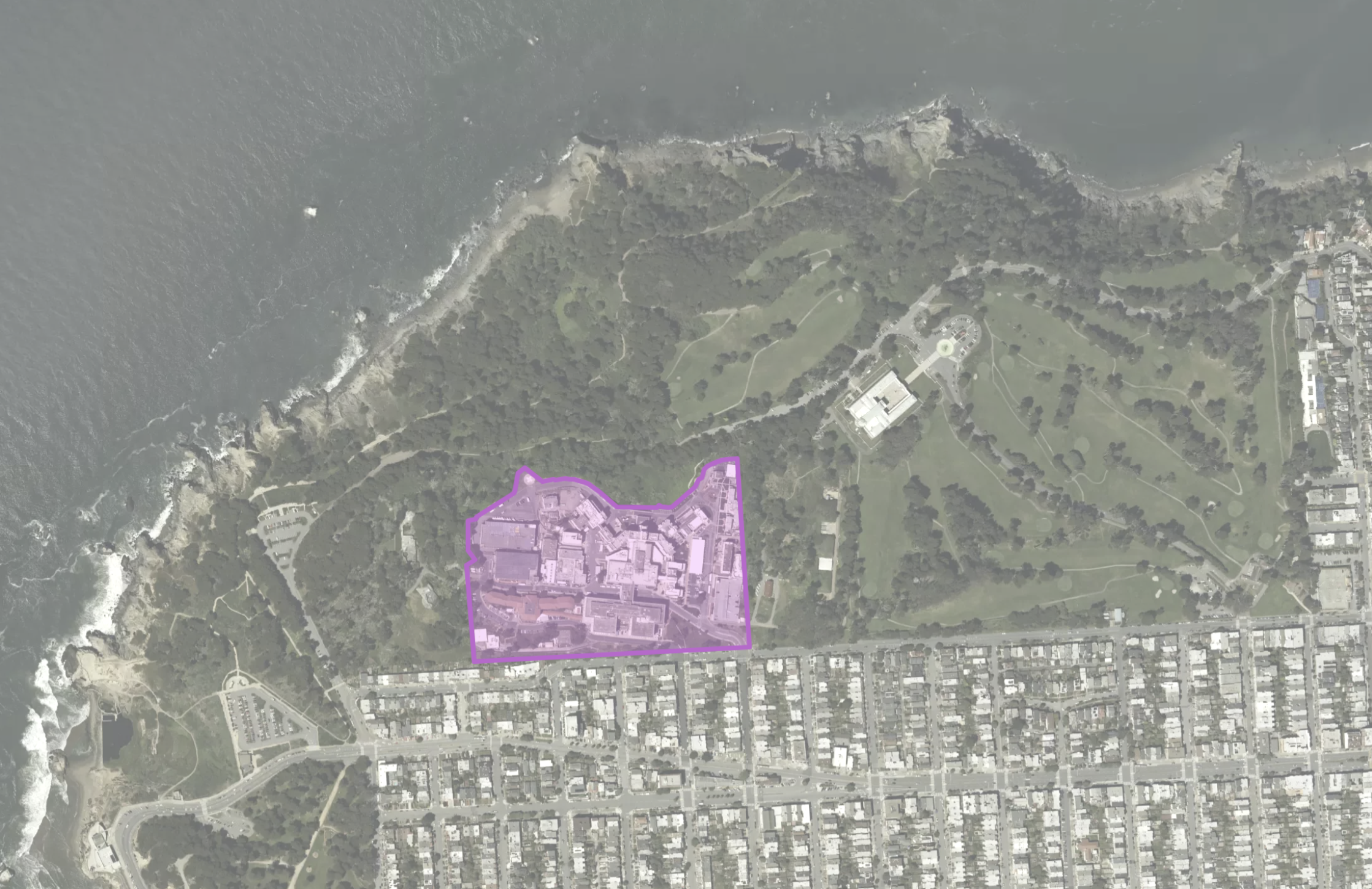
San Francisco VA Medical Center — example of hospital campus polygon data included in the Comprehensive version.
© OpenStreetMap
(scroll down to see all fields)
| fieldname | description | Basic | Pro | Comp. |
|---|---|---|---|---|
hospital |
Hospital facility name (cleaned, title case). e.g. "Stanford Health Care" | |||
hospital_alt |
Alternate or former hospital name. | |||
address |
Street address from Medicare data. | |||
city |
City name. | |||
state_id |
State abbreviation. e.g. "CA" | |||
zip |
ZIP code from Medicare data. | |||
emergency_services |
Whether the facility has emergency services (TRUE/FALSE). | |||
ownership_type |
Ownership classification. e.g. "Voluntary Non-Profit - Private", "Government - State" | |||
bed_count |
Total number of licensed beds. | |||
id |
The unique identifier (CMS Facility ID) used by Medicare to identify the hospital facility. | |||
lat |
Latitude (4 decimals, WGS84). e.g. 37.4439 | |||
lng |
Longitude (4 decimals, WGS84). e.g. -122.1710 | |||
phone |
Phone number in (XXX) XXX-XXXX format. | |||
website |
Primary hospital website. | |||
type |
Hospital type from Medicare. e.g. "Acute Care Hospital", "Critical Access Hospitals" | |||
trauma_level_adult |
Adult trauma level designation, coded as an integer. e.g. 1, 2 | |||
trauma_level_child |
Pediatric trauma level designation, coded as an integer. e.g. 1, 2 | |||
county_fips |
FIPS code of the county containing the hospital. | |||
county_name |
Name of the county containing the hospital. | |||
cbsa_fips |
Core Based Statistical Area (CBSA) FIPS code. | |||
cbsa_name |
Name of the CBSA (metropolitan or micropolitan area). | |||
cbsa_metro |
TRUE if the hospital is part of a metropolitan (rather than micropolitan) statistical area. | |||
csa_fips |
Combined Statistical Area (CSA) FIPS code. | |||
csa_name |
Name of the Combined Statistical Area. | |||
geometry |
GeoJSON building footprint (Polygon or MultiPolygon) from OpenStreetMap. Only available in GIS files. |
What hospitals are included?
The database includes hospitals and medical facilities certified by the Centers for Medicare & Medicaid Services (CMS), covering acute care hospitals, critical access hospitals, children's hospitals, psychiatric facilities, and more across all 50 states and D.C.
Where does your data come from?
Hospital records and tabular data are sourced from CMS Medicare certification data. Geographic relationships (county, CBSA, CSA) are derived from US Census Bureau data. OpenStreetMap is used exclusively for hospital building footprints (polygons) included in the Comprehensive GIS files. We've made a concerted effort to source our data from public domain and permissively-licensed sources.
Is the Basic (free) version sufficient for my needs?
The Basic (free) database will meet many users' needs. You may want to purchase the Pro or Comprehensive versions if:
What is the difference between the Pro and Comprehensive versions?
Both Pro and Comprehensive include the same data fields and number of entries (5,768 hospitals). The key differences are:
Am I allowed to redistribute the database if I purchase a paid licence?
CSV/Excel/SQL: A licence allows you to use the database internally or to query it for public-facing applications that you or your organisation owns or develops. Attribution is not required. You are not allowed to publicly redistribute the database without prior permission. You can make copies for internal and backup purposes.
GIS Files (Comprehensive only): The GIS files are derived from OpenStreetMap and are made available under the Open Database License (ODbL). You must attribute "© OpenStreetMap" when using these files. Unlike the CSV/Excel/SQL files, the GIS files may be redistributed provided you do so under the same ODbL license. To learn more, read the full licence terms.
Why should I trust this data?
This database was aggregated from authoritative sources and carefully processed by SimpleMaps. We've been developing and selling interactive maps to Fortune 500 companies and prominent international organisations for over 16 years. Over this time, we've learned a lot about geographic data. To get a sense of the expertise, check out some of the testimonials from our happy customers.
If I use the free database, what type of attribution is required?
If you use the Basic (free) database, you must link back to this page:
https://simplemaps.com/data/us-hospitals
from a public webpage where you are using the data. If you want to use the data internally, you must link back to this page from your firm's website on a page that can be easily found through links on the root domain. The link must be clearly visible to the human eye.
How often do you release updates?
We monitor our sources and release new versions when we have more current data. Upon purchase, you can elect to receive email alerts when we release new versions.
Can I purchase additional updates?
Yes. After updates expire, you can purchase 12 more months of updates for $199 (Pro) or $499 (Comprehensive).
Home (Maps) | Database License | Privacy | Database Releases | Database Order Lookup | Resources | Contact | FAQs
SimpleMaps.com is a product of Pareto Software, LLC. © 2010-2026.